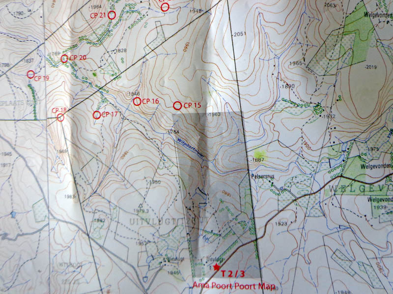
Although I didn’t race HighlandTracks, a 150km race presented by Team Lickety Split (William Cairns with Sue Belcher and Mike and Con), I did play around on the second (of three) trekking legs and I collected checkpoints from this section once all teams were through. The Dullstroom area is lovely, the waterfalls are spectacular and the checkpoints were located at enjoyable (for the view or feature) sites, I came away from the race just super impressed with what Sue Belcher did with the map of a section of the second trekking section.
Being a navigator and orienteer, maps are my thing.
I think it is an absolute waste of time to drive through to a race after work, spend X-amount of hours plotting check points (CPs), to sleep for an hour or two and then to start racing. Pre-plotted maps are the way to go and fortunately these days we rarely have to plot. The Highland Tracks maps were pre-plotted and very neat and tidy.
We’re in a digital age. We have, at our fingertips, digital 1:50,000 topographic maps of the whole country. There’s absolutely no need to have many government-printed topographic map sheets (sometimes your route may only cross a corner of one) when race organisers can join and crop maps on computer to fit to page for printing. The maps for this race were printed on two A3 sheets.
The Highland Tracks maps were printed on waterproof paper. This paper is commonly used for orienteering maps and will stand up to quite a bit of wetting. You need only be cautious of the folds as this is where the ink can rub off. Add a zip-seal bag or a mapcase and you’re ready for a dunking.
Maps must be updated by race organisers with new roads or tracks. Many of our topographic maps are old and in some areas there has been infrastructure improvement. Finding roads, tracks and footpaths should not be left to luck; there’s no navigation skill in luck. A team may stumble across a good track by pure chance, while another is 50 metres to the right and they spend the night fighting through vegetation. Features like these, discovered by race organisers during scouting (on the ground and using tools like Google Earth) must be represented on the race maps. We’ve got GPS units to log tracks, there’s Google Earth to visualise where these logged tracks tracks lie… Adding the track to a digital topographic map is easy and can be done in any graphics program. It doesn’t have to be 100% accurate to the metre, after all maps are a representation, not a replica; it just has to show that there’s something there that is advantageous to use.
Control descriptions are used in orienteering to provide more information about the location of the control. It may be ‘Ruin, East inside corner’ or ‘Stream Path junction’. When you’re dealing with features like cliffs and waterfalls you need to know whether the CP is at the top or bottom; a feature next to a river should be clarified with river left or river right so that the team can approach from the correct side. Accurate control descriptions are essential, especially where there are many similar features in an area.
William did provide control descriptions – I didn’t see them directly; I picked them up second hand from Mark’s map. We kept each other company out hiking and looking for teams. Most control descriptions were perfectly adequate; a few needed a dash more of specificity. “Waterfall” would have better been described as “Bottom of waterfall in kloof” and “Tree in kloof” would have been better described as “Tree in kloof, river right”. We actually went river left, as indicated by the hiking trail on the map. You can’t get to the tree from river left.
And to save my greatest delight for last…
Custom maps are beautiful, especially for smaller areas with interesting features that the race organiser wants to utilise. At a 1:50,000 scale there’s just not much space nor detail to distinguish closely located CPs. I saw a 1:50,000 map last year from a school AR event that had so many CPs stacked on top of each other that they could barely be differentated; painful navigation. Barely navigation really. The solution to this scale thing is simple. Blow up the map and add in some detail.
And this is just what Sue Belcher did with the hiking trails on the Ama Poort Poort property through which the race passed. This farm had\s trout dams and hiking trails with rivers, waterfalls and kloofs. William placed a number of controls on this property – for the rogaine-style hiking leg – and Sue created a custom map of the property. She said that the farmer’s original hiking map was just plain nasty so she created this new one, including his “Points of Interest”, which she has given to the farmer to use and to replace his old, inaccurate ‘map’.
I also love that Sue used shading on the topographical map to define the area depicted by the hiking map insert. Sue, I’m so getting you into making orienteering maps…
I can’t comment much on the race course although I’ve heard nothing but positive comments from participants. But I can send out a hearty congratulations to William and Sue for really super topographic maps. You’ve checked all my boxes. Well done.
Author: Lisa de Speville, control collector | Highland Tracks, 26-27 January 2013.
Some of my photos from playing around out there are on my AdventureLisa blog.
